Location
Knowing a tree's location is essential for doing follow up measurements and doing spot checks to assure that your data collectors are providing good data. In order to get good location data for all trees you must decide what system you plan on using. As technology continues to advance GPS coordinates will become more prevalent but other low tech systems involving maps or addresses and codes are just as functional.
GPS
If you are using a GPS recording the latitudinal and longitudinal coordinates will be sufficient for future crews to follow up with. It should be noted that GPS units have varying degrees of accuracy and can be affected by tall buildings or overhead obstructions.
Address
If you are using the address a tree is located you will encounter situations where there are multiple trees at one address, and circumstances could occur that warrant recording multiple vacant planting sites at a single address. In order to differentiate between different trees or planting locations a code system is often used such as the one detailed below. It can be used in full, or as a framework to build your own.
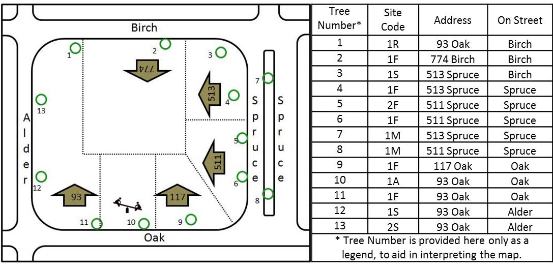
This system is specifically designed for street trees. For each tree the address is recorded, and a code is assigned. Tree site codes are numbered sequentially on each side of a lot in the order of ascending addresses. Trees on the front of the property are indicated by an “F”, the side of the property are indicated by an “S”, trees at the rear by an “R” (this is used for lots that span the entire block), trees in an adjacent property without an address an “A” (e.g., vacant lots, small parks/gardens), and trees on a median by an “M”. Multiple trees and planting sites can exist at each address. For example, a given address could have trees 1F and 2F, and the next house would begin anew with 1F. For trees on the side, rear, or adjacent to the house itself, the numbering system goes in order of ascending addresses on the street where the tree is located (see trees 12 and 13 below). A separate series of tree site code numbers exists for each side of a property.
GPS
If you are using a GPS recording the latitudinal and longitudinal coordinates will be sufficient for future crews to follow up with. It should be noted that GPS units have varying degrees of accuracy and can be affected by tall buildings or overhead obstructions.
Address
If you are using the address a tree is located you will encounter situations where there are multiple trees at one address, and circumstances could occur that warrant recording multiple vacant planting sites at a single address. In order to differentiate between different trees or planting locations a code system is often used such as the one detailed below. It can be used in full, or as a framework to build your own.
This system is specifically designed for street trees. For each tree the address is recorded, and a code is assigned. Tree site codes are numbered sequentially on each side of a lot in the order of ascending addresses. Trees on the front of the property are indicated by an “F”, the side of the property are indicated by an “S”, trees at the rear by an “R” (this is used for lots that span the entire block), trees in an adjacent property without an address an “A” (e.g., vacant lots, small parks/gardens), and trees on a median by an “M”. Multiple trees and planting sites can exist at each address. For example, a given address could have trees 1F and 2F, and the next house would begin anew with 1F. For trees on the side, rear, or adjacent to the house itself, the numbering system goes in order of ascending addresses on the street where the tree is located (see trees 12 and 13 below). A separate series of tree site code numbers exists for each side of a property.